Katy area prepares for Tropical Storm Nicholas
The Katy area is under a tropical storm warning as Tropical Storm Nicholas approaches the region with heavy rains and some winds expected over the next 48 hours according to area emergency management …
This item is available in full to subscribers.
Attention subscribers
To continue reading, you will need to either log in to your subscriber account, or purchase a new subscription.
If you are a current print subscriber, you can set up a free website account and connect your subscription to it by clicking here.
If you are a digital subscriber with an active, online-only subscription then you already have an account here. Just reset your password if you've not yet logged in to your account on this new site.
Otherwise, click here to view your options for subscribing.
Please log in to continue |
Katy area prepares for Tropical Storm Nicholas
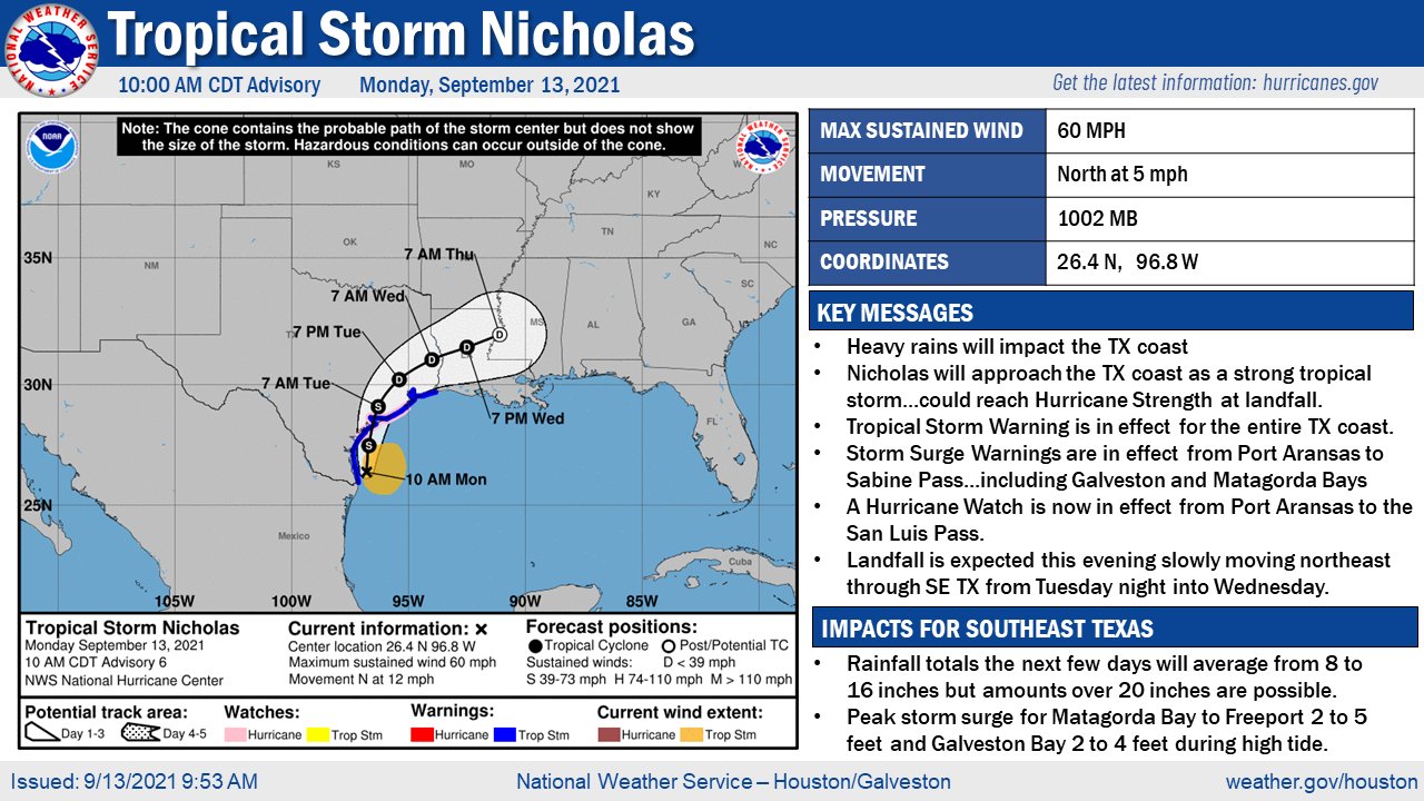
The Katy area is under a tropical storm warning as Tropical Storm Nicholas approaches the region with heavy rains and some winds expected over the next 48 hours according to area emergency management officials and meteorologists.
“While rainfall totals are indicated over the 5-7-day period, much of the rainfall is expected to fall over a 2-3 day period starting later tonight.,” said Harris County meteorologist Jeff Lindner.
Locally, the National Weather Service is predicting a high near 84 degrees today with winds wetween 15 and 25 mph. Through Tuesday, several inches of rain are possible with possible heavy winds. Rain is expected throughout the day going into Wednesday morning, provided Nicholas remains on its current course.
Officials are urging residents north of I-10 to take the storm seriously and be prepared for any changes in Nicholas’s path and for saturation of the ground causing flash flood risks throughout the Katy area and surrounding counties.
“Currently, Fort Bend County is under a flash flood watch in effect through tomorrow evening,” said Fort Bend County Judge KP George during a Monday morning press briefing. “We know that one of the things about these storms, as you all know, (is that) it is very unpredictable. It is (possible) for Tropical Storm Nicholas to get stronger.”
Fort Bend County Emergency Management Director Mark Flathouse said the county’s Emergency Operations Center had been activated and that county officials are monitoring the storm closely. Planning for the storm is erring on the side of caution he said and he encouraged all area residents to ensure they were prepared for the storm with enough fuel, food and other supplies for the storm. He also encouraged residents to pick up any items left in their yards which may become windblown debris if high winds occur more inland than they are currently expected to.
Detailed information on how to prepare for a tropical storm or hurricane may be found on the National Weather Service’s website.
Lindner said areas between Galveston Bay and Matagorda should expect to see 65-75 mph winds with heavy winds going inland to the US 59 corridor.
Fort Bend County Deputy Emergency Management Coordinator Alan Spears said residents near Addicks and Barker reservoirs should not be overly concerned about the reservoirs overflowing.
“As in the past, I know some people are concerned about the Addicks and Barker reservoirs, but we’ve been in touch with the Army Corps of Engineers,” Spears said. “Both reservoirs are empty right now, so they have a very good capacity for water right now.”
Waller County is expecting less rain, but Waller County Judge Trey Duhon urged county residents to exercise extra caution and be aware that the path of the storm could swing more inland than currently projected and he also encouraged citizens to take precautions but remain calm.
“There is no need to panic. We all know the drill,” Duhon said via Facebook. “Prepare for some wind and possible rainfall. As dry as it has been, the ground will absorb quite a bit of the rain, and if the rain is spread out over a few days, (Waller County) should be fine. Street and road flooding will be possible, so stay tuned to local authorities during the storm.”
Katy ISD is closing all campuses and related activities after 6 p.m. tonight in preparation for the storm and school is canceled for Tuesday, Sept. 13.
Royal ISD has also canceled classes for Tuesday and all after-school activities for Monday.
STORM INFORMATION RESOURCES
CITY OF KATY:
City of Katy Office of Emergency Management
CITY OF BROOKSHIRE:
Brookshire Police Department Facebook page
CITY OF PATTISON:
FORT BEND COUNTY:
Fort Bend County Office of Emergency Management
Fort Bend County OEM Facebook page
Fort Bend County Office of Emergency Management Twitter feed
HARRIS COUNTY:
https://www.harriscountyfws.org
Harris County text alerts via ReadyHarris.org
Text GULF2021 to 888777
WALLER COUNTY
https://www.facebook.com/WallerFMO
https://www.facebook.com/wallercountysheriff
https://www.facebook.com/WallerCountyRoadandBridge
Report road flooding to the Waller County Sheriff’s Office by calling 979-826-8282.
Keywords
Tropical Storm Nicholas


